|
|
|
|
|
|
|

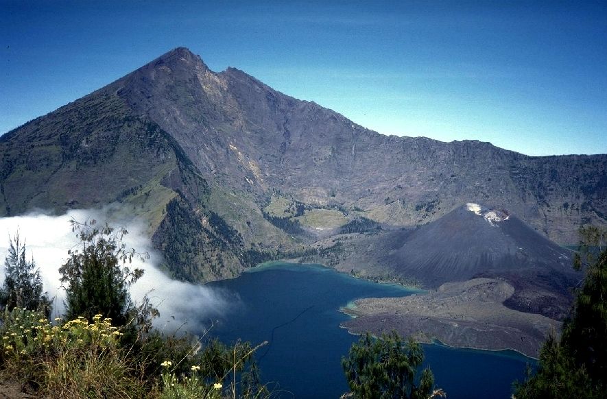
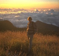
From the crater ridge in the highlands of Gunung Rinjani, Lombok.
My climb of Mount Rinjani (Gunung Rinjani) on the island of Lombok in Indonesia is still one of the most amazing landscape experiences I ever had!
I flew from Australia to Bali and continued by buses and boats across Lombok – Sumbawa to Flores in the east. Part of the way back was made onboard a fishing boat from Flores to Lombok together with a group of other rucksack tourists. The trip took 4 days, but we were not in a hurry. On the way, we visited the islands of Rinca and Komodo (famous for the Komodo dragons) and anchored in small idyllic bays where those who liked it jumped into the water and snorkeled. But it was quite OK just to sit on the deck watching the blue mountains of Sumbawa and all the other big and small islands we passed.
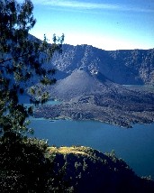
In the morning of day 4, the enormous silhouette of Rinjani turned up in the misty morning. Rinjani is an app. 3.700 m. high vulcano, temporary active – last time about 5 years ago. Under the summit, there is a big lake with its water level at an altitude of 2.000 meters – and in the middle of the lake you will find a smaller, temporary active volcanic cone.
The main trail leading to the top starts at the village of Senaru, which is the last accessible site for vehicles. On the way up, you will walk through beatiful mountain forests filled with mystery, mists, lichens and wild monkeys. In fact, there were so many monkeys, that it was sometimes a problem to eat our lunch or dinner in peace!
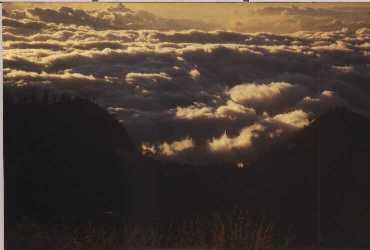
When you reach 2.000 meters above sea level, the forest disappears and reveals an incredible view! From my tent above the forest, I watched the sun go down into a dune of clouds. In the far distance, about 100 km away, I could see the summits of two high vulcanoes on Bali. And after 20 minutes climb upwards from my camp, I reached the crater ridge with the big lake in the bottom.
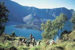
The next day, I descended to the lake in the crater. This is only possible from one place on the ridge: By a narrow and very steep path clinging to the crater wall, leading 650 meters down. The trip down and back to the ridge takes 4 – 5 hours. Remember, that descending and ascending 650 meters from an altitude of 2.000 meters is quite a trip! But the reward is great. The scenery on the whole trip is unique, and by the way: The water in the lake turned out to be quite warm and very pleasant for swimming in spite of the high altitude, owing to the active vulcano!
It takes 3 or 4 days to climb Rinjani, depending on whether you want to climb the summit at about 3.700 meters or whether your ambitions will be satisfied at the crater ridge. Most of the trekkers hire one or more porters + equipment in the village of Senaru, which is cheap and advisable. But no matter how you plan the climb, you should never go to Rinjani during the rainy season.
|
|
|
|
Click HERE to see my digital photos from Madeira.
Click HERE to see my digital photos from Gambia and Senegal in West Africa, February 2004.
Click HERE to see my digital photos from a trek in High Atlas, Morocco, September 2003 (text in Danish).
Click HERE to see selected photos from my numerous travels all over the world.
Click HERE to read and watch the photo gallery story about
my overland trip along The Hippie Trail from Copenhagen Central Station to Kathmandu in Nepal.
If you want to see the English version of my home page with exciting and interesting articles about travelling and trekking, please click HERE